Protect yourself and your loved ones by buying our products from our Indiegogo campaign.
They couldn't make a cell phone call for help, but we could!!!
 |
| Successfully making a cell call where the phone without our Signal Enhancer indicated no service |
We drove from San Jose, California to Lovelock, Nevada on Saturday, December 28, 2013 in a Ford Explorer and reached town about an hour and a half before sunset. We didn't want to waste daylight, so we drove around the outskirts of town taking cell phone signal strength data with the DOTS911 app, recording red (no service), yellow (marginal service), and green (usable service) dots every 1/4 mile on a map. In Lovelock we saw good coverage, indicated by exclusively green dots.
We planned to drive across 15 miles of high desert between two mountain ranges the next morning, so we filled up with gas (cheap, compared to California) at Two Stiffs Selling Gas, and had a very good dinner at Sturgeon's Inn and Casino, then slept in the Royal Inn across the street. The next morning we had a continental breakfast and I went out to walk around town, which was quite charming. True to its name, Lovelock has a series of chains behind the courthouse to which have been attached thousands of locks engraved with the names of visiting couples.
I was hoping to find some knowledgeable locals who could give me directions to the spot where a Jeep carrying two adults and four children recently overturned and set into motion a widely publicized saga of desperate survival and a huge search and rescue effort. I got lucky in front of the Cowpoke Cafe, where I found a cluster of locals, one with a white hat. I introduced myself and explained what we've developed with the DOTS911 phone app and Signal Enhancer and our interest in testing it in the area to see how much our products would have helped the recently stranded party. As I might have guessed, the man in the hat was Richard Machado, the Pershing County Sheriff who had, with two of the other men in standing next to him, directed the search and rescue effort. These were exactly the people I wanted to find.
After listening to my explanation, the group was skeptical. Sheriff Machado said there is absolutely NO cell signal in the Seven Troughs area anywhere near the site of the incident. I explained that I have been able to make cell calls in several locations where others had been stranded and found that usable signals exist in unexpected places, especially when using our signal enhancer. If the stranded party could have made a call, it might even have been to a tow service instead of 911, eliminating the involvement of emergency services and more specifically avoiding costly efforts from the 200-person search and rescue team, the emergency vehicles, the helicopters, and the civil air patrol flights. Sheriff Machado gave me directions to the site and agreed that if our products actually would allow a cell phone call from the area then they would have made a huge difference for the stranded group and for taxpayer-funded emergency services. He thanked me for the work DOTS911 is doing and I set out to follow his directions into the high desert.
 |
Pershing County Sheriff Richard Machado
|
We set out for highway 399, which we followed to the beginning of the 15 miles of dirt road across the desert to the Seven Troughs mountain range. Take a look at the picture of our data from the area.
 |
| Signal strength data from Lovelock (in the southeast) to the Seven Troughs area |
We saw green dots indicating usable cell service until the beginning of the dirt road 15 miles outside of town. At that point, as Sheriff Machado had described, our service disappeared. Notice, however, that the map shows a few yellow and green dots after the transition to the dirt road. When you're in an area with very little or no signal, it's not uncommon to see some signal dots that show a varying signal that comes and goes. If you stop moving and watch your phone, you might see no service, no bars, then 1 bar, 2 bars, no bars, and then no service again. If you try to make a call with this kind of marginal signal your phone will usually immediately switch back to showing no service.
However, these marginal signals do represent some communication between the phone and a service tower. It often doesn't take much of an improvement to convert this fluctuating and unusable signal into something steady enough to make a call. Our Signal Enhancers are designed to do exactly this. Remember, though, that this isn't magic: amplifying a very weak or nonexistent signal is not a guarantee of success. Zero multiplied by anything is still zero.
With that said, when we stopped to test our Signal Enhancer at one of these detectable but unusable signal locations, we immediately saw success. Without the Signal Enhancer we saw the behavior described above - a ghost signal that didn't let us make a call. With the Signal Enhancer we easily made a call out of the area. We've marked this location on the map. We were on a tight schedule to get back to the Bay Area that evening and the directions we had to the site of the overturned jeep weren't specific enough for us to know where to best demonstrate the DOTS911 products, but it's a huge success to have traveled into an area where Sheriff Machado has seen no phone service in his extensive history in the area and then make a call.
If the stranded party had the DOTS911 app and Signal Enhancer, we would have never heard of this nearly disastrous ordeal. They would have been able to take a short walk and call for help. There wouldn't have been headlines, there wouldn't have been a search and rescue effort, and two adults and four children wouldn't have had to spend two days in frigid weather, hoping for others to find them. We want to change this sort of fatal or nearly fatal incident into something much less dangerous, and we'd rather put your successful rescue stories on our website than see them in national news. See our Indiegogo Campaign
A few days after our trip we spoke with Sheriff Machado over the phone. He's enthused about our success and the number of lives it could save. Now that he clarified the site of the jeep, we may take another trip to test our products closer to the initial accident and demonstrate a phone call from this previously zero service area to local search and rescue leaders.
Check out some additional photos from our trip:
 |
| Round Courthouse |
 |
| Chains with Lovers' Locks |
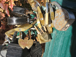 |
| Locks |
 |
| 399 North of Lovelock |
 |
| Turn onto the Seven Troughs dirt road |
 |
| Fork in the road in the high desert |
 |
| Wild mules? |
 |
| Approaching the Seven Troughs mountains |
 |
| Crossing Seven Troughs mountains |
 |
| Mountain ranges further to the west |
 |
| Returning to green data dot |
View from the green data dot location where we made our call
 |
| Drive to Seven Troughs ghost town (a yellow dot location) |
 |
| Back to civilization on highway 399 |
 |
| Returning to California |
Look at our Indiegogo Campaign


No comments:
Post a Comment